 |
|
Bulkley
Valley Topographic Mapping
|
|
The classic 1:50,000 topographic maps from Natural Resources Canada are every hiker's friend. Unfortunately, in our area they have not been updated since the 1990s, or in some cases not since 1975. They have also become difficult to find. For example, below on the left is the Twin Falls area as shown on the 093L/14 quadrangle, dated 1975; and on the right as it is today, with its recreation site and trails. 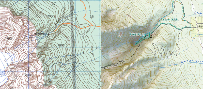 Maps on phones are popular, but as another option for outdoorspeople I have made a new series of printed topographic maps of the upper Bulkley Valley using current data. They are for sale on a print-on-demand basis at Bulkley Valley Printers in Smithers. The maps are at 1:35,000 scale, and 165 sheets cover the entire area of the old 093L quadrangle. (This includes most of the mountains and lakes typically visited from Smithers, Telkwa and Houston. See the index to mapsheets, below.) They are printed on 11" x 17" paper, so each map covers an area about 9 km x 14 km. Print-on-demand means you buy only the map sheets that you want. Each map will be $8 if printed on 24 lb bond, or $12 printed on 6 mil synthetic (a paper that is weatherproof/waterproof). |
Some of the features of this
series include:
|
 |
| Shaded relief
The shaded
relief is based on the Shuttle Radar Topography Mission around
the year 2000. I used a combination of the Blender and
Skymodel hillshading methods.
|
 |
Recreation
sites, selected trails and private land
Recreation
sites are from current provincial data. Private land is tinted
yellow, and comes from ParcelMapBC.
Trails,
however, are trickier to come by. There is no provincial
database of trails, so what is shown on these topos is the
collection I have made of trails over the past twenty years.
As well, they show the trails from the old NRCan topographic
maps (as "historic trail"), plus a few routes of travel where
there is no trail, but navigation is either straightforward or
follows flagging.
As a caveat,
there are certainly trails that are not on these maps, and
some trails shown on these maps may no longer exist!
|
 |
Park
boundaries
|
 |
Forestry
roads
Where a Forest
Service Road has a name, I've endeavoured to show that. I have
not labelled all of the tiny branches that lead off them.
|
 |
Cutblocks
Cutblocks
replanted less than twenty years ago (i.e., since 2001) are
shown as non-forested.
Because each
individual map is small, there are 165 different sheets in the
series, as shown on the mapsheet index below. Click on the image
to download a full-size PDF (13MB).
|
 |
You can also
click on the legend below to download a page-size version.
 |