 |
|
Mapping
Gottfried Merzbacher's The Central Tian-Shan Mountains,
1902-1903
The map below is 1200 pixels wide, and works best on screens that are wider. All features are listed in alphabetical order by the name that Merzbacher uses for them in the text. Linear and area features are listed with rivers first, alphabetically, followed by areas, and finally Merzbacher's route.
|
|
This map was
created using GPS
Visualizer's do-it-yourself geographic utilities. |
|
Data
Download Merzbacher's route as KMZ or shapefile. Download a glossary (PDF) of geographic terms for this area. Download geographic data for point features Merzbacher mentions (settlements, peaks, passes) as CSV or KMZ. Download geographic data for linear features Merzbacher mentions (rivers), and area features (mountain ranges, lakes), as shapefile or KMZ. Download a list of references for this project (PDF). (For the internal structure of these files, see data notes, below.) Commentary
Gottfried Merzbacher was a German geologist of the late 19th century who made a trip in 1902-1903 to the Central Tian-Shan mountains — today on the border between the Kyrgyz Republic and China — to try to solve a number of geographic puzzles. One of these puzzles was that no one knew where the impressive peak of Khan Tengri was — or, rather, they had placed it on maps but these maps were wrong. It was something he immediately saw when he got there. Did Khan-Tengri rise at the spot, where in the forty-verst map and in all other maps, it is represented, its pyramid must inevitably have been seen from our standpoint. All we learned by our excursion was therefore only the confirmation of the opinion, previously suggested, namely, that in this cardinal point the maps were all of them at fault. The task therefore devolved on us to determine the actual situation of Khan-Tengri. [pp. 17-18] You could see Khan Tengri — Lord of the Skies in Kyrgyz — from many vantage points far away, rising as a distinctive pyramid higher than anything else in the range, but as you approached it the peak disappeared behind nearby ridges. Second, many of the glaciers on the north side of the range fed a river that flowed south into the heart of the range, so... where did it go? Which river flowing out of the range on the south side was it? Last, were the current maps correct in other respects, like the naming and placement of rivers and mountain ranges? To do all this he essentially moved to the Tian-Shan for two years, at times accompanied by climbers and guides from Austria and Germany, and sometimes by Russian Cossacks assigned to him, and always by local people hired to carry his goods and instruments: the "caravan," as he called it. He was working with the Russian Geographical Society, and seems to have had their support; he never mentions any kind of equivalent Chinese body, and in fact at this time Chinese rule over Xinjiang was not strong. When in China he seems to go where he pleases and without much help from the authorities. For me, the project was to take the 1905 English edition of his book, The Central Tian-Shan Mountains, 1902–1903, and figure out three things:
In practice the second and third projects had to be done alongside the first. For example, on p. 18 Merzbacher writes, Beyond Sary-jass-tuty station you leave the river-bed of the Chalkody-su, and, crossing the mountain chain through the glen of Tute, enter the uppermost valley of the Tekes. To figure out his route you have to determine that Sary-jass-tute station has now become the town of Saryzhaz, confirm that the Chalkody-su river runs by there, and find the "glen of Tute" on an old Soviet map as ур. Туте (ур. being an abbreviation for урочище, area). Along the way you discover that sary is the Kyrgyz word for the colour yellow, and su means water or river. So all three sub-projects proceed together. This being Central Asia, a lot of things have changed names since 1905, and pretty much the only thing which is definitely the same is the landscape. We can, for example, look at OpenTopoMap, with its elevations based on Shuttle Radar Topography Mission, and see the same topography that Merzbacher walked over — although we have to allow that a few glaciers have probably changed their lengths. Merzbacher is fun. He's not going to be everyone's cup of tea, because his prose is frequently "embattled," to quote Bruce Chatwin describing the writing of Joseph Rock, an early twentieth century American travelling in Yunnan. At his worst Merzbacher is the impenetrable geologist. In these clay and marly uplands we again find, crowded together in a narrow, readily overlooked space, the same varied features in valley and hollow, the same manifold conformation of mountain and surface as are presented by the high ranges in wide inaccessible areas, of which we can obtain no comprehensive view. Many of the processes that there took place in a large way, have here been repeated on a small scale. In a word, the mountain-shaping and mountain destroying forces have combined to produce a relief, which offers an instructive object-lesson on orographic structure, so far as regards the diversified character of the surface modelling. [p. 100] But at his best he paints a word-picture for us of all the landscapes he travels through, and it is the landscape itself he is trying to figure out. Alpine meadows, dressed in flora of surpassing beauty, adorn the wide, high-lying floor, strewn with debris. In its midst there rises up every year, from May to October, a spacious town of metal houses and wooden booths—the famous yearly market, that is of such great importance to the extraordinarily numerous Kirghiz population of the Tekes, Chalkody-su, Kegen, and Charyn region. Thousands of Kirghiz tents collect in a wide circle around the wooden town. This is the mart where the Kirghiz exchange their products of wool, hides, sheep, and horses for the manufactured goods, exposed for sale by dealers mostly of Tartar race. Here, in a secluded green Alpine bottom, completely withdrawn from the highways of the world, walled in by mountain chains glittering in glacier snow, the traveller may admire a lively tumult of business and contemplate modes of commerce, belonging to an epoch of culture, unknown for centuries past in Europe. Here he may study scenes of a picturesque charm, not to be easily surpassed anywhere else. During the four months of the yearly market the seat of the administrative authorities of the regions in question is transferred to this spot. [pp. 11-12] His book did come with a map. The German edition had a map with names in German transcription. E.g., Sary-Dzhaz, rather than Sary-jass. The English edition has a re-issue of the same map but with names in English transcription. 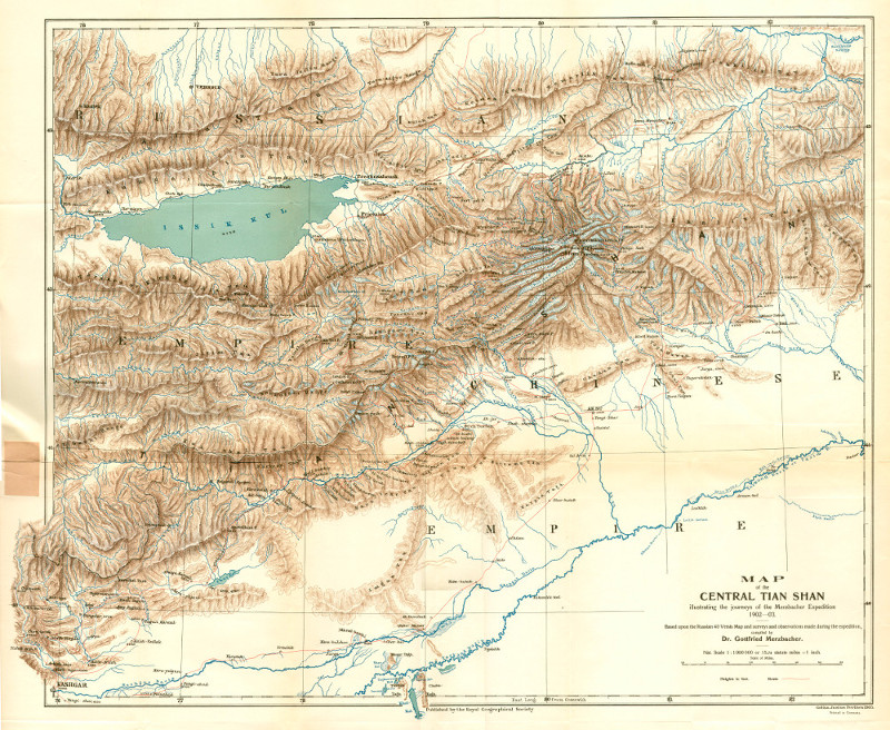
[This is the version of his map that came with the English edition, and can be downloaded from the Pahar.in page for Central Asian maps after 1900. The map from the original German edition can be downloaded from the Gunnar Jarring Collection.] It's a good map, and it helps us decipher a lot of the places he names. But it too has a few errors, in places where Merzbacher himself did not go. We'll see this when we zoom in on some details. However, finding errors Merzbacher made was not really my goal: I was interested in figuring out where he went. Here is a summary of the book, just to provide an overall structure to the data.
Summary
PART ONE (Chapters I – V)Merzbacher's initial move is to position himself in front of the middle of the north side of the Tian-Shan range. He travels from Przhevalsk to the village of Narynkol. He spends a bit of time mucking about in an area he calls the Mukur-mutu valleys, and then he heads south up the Bayumkol River into the heart of the range. Here he gets his first views of Khan Tengri. Just before reaching the mouth of the side valley of Ashu-tyr, and behind a belt of wood which stretches diagonally across the main valley, the magnificent pyramid of Khan-Tengri suddenly comes into view. The mountain looks so near as to convey the illusive impression that it is planted in the background of the Bayumkol valley. Arriving at the end of the great granite rockslip, lying on the top of the first ancient terminal moraine at the debouchement of the lateral valley of Alai-aigyr, one sees, far below, the middle course of the Bayumkol valley as a forest-encircled basin with a quite level bottom ; here, on the other hand, the view is magnificently closed by Khan-Tengri, and it seemed again as if at the end of the Bayumkol valley we should reach the foot of the giant mountain. There we found indeed the head of a valley, exhibiting magnificent glaciers and a circle of very high mountains clothed with ice from their feet to their summits, but Khan-Tengri was not among them. Spending a couple of weeks in the Bayumkol, he learns about weather patterns (there are storms most afternoons) and his porters (they mostly quit). He crosses a pass into the valley of the Semenoff Glacier, which runs west, and spends most of the summer coming to understand the topography of the Semenoff, Mushketoff and Sary Jass valleys. In the course of this he discovers the magnificent Marble Wall, and a few places from which he can see Khan Tengri. He establishes that Khan Tengri does not sit anywhere along these glaciers.
PART TWO (Chapters VI and VII)With fall coming on, Merzbacher returns to Narynkol and then sets off in September of 1902 for the south side of the range. Crossing the Great Musart River, which he must ascend to get to the Musart Pass, one of his pack animals stumbles and dumps its load in the water, ruining many of the photographs which the expedition had taken in the previous months. The Musart Pass is a historic and well-known pass. It's about 100 km from the north side of the Tian-Shan to the south side, so we could compare this journey to crossing through the Rockies by walking from Tete Jaune Cache, British Columbia to just past Jasper, Alberta, where the Athabasca River issues from the mountains. When he comes out of the mountains on the south side, he heads for the nearby Chinese city of Aksu, and then on to Kashgar.
PART THREE (Chapters VIII–X)In October of 1902, “the expedition took up its winter quarters in Kashgar.” It must have been a delight for Merzbacher to know he was going to winter over in the Tian-Shan, or near the Tian-Shan, and could make the most of every moment. So while Herr Pfann (the engineer from Munich who has done much of the surveying on the trip so far) and Herr Russel set out for Tashkent and home, Merzbacher uses the early winter to look for fossils along the south margin of the Tian-Shan. He goes up to the village of Artysh, and ascends what he calls the Toyun River (although most maps today call this the Chakmak). He then goes up through the Tangitar gorge to Tegermen, and sees some old lake beds and Tertiary ridges. Passing through Bash Sugun, he comes down the Sugun (or Kurumduk) River and back through the plain around Kalta-Yailak. He then has to go to Tashkent himself “during the prevalence of the severest winter weather” because there is no telegraph in Kashgar, and he must pick up things ordered from Europe and summon a second alpine guide (Stockmayer) from Austria. He's back in Kashgar in March, and the party is now eight: Merzbacher, the geologist Keidel, two alpine guides from Austria (Stockmayer and Kostner), Maurer the preparator, and three Cossaks lent by the Russian government: Besporodoff, Simin and Chernoff. In April they head back up to Bash Sugun, but this time go east through the Jai-Tyube region and over the Apatalkan pass to the Kok-shaal River (aka the Taushkan River). This river runs east, parallel to the main spine of the Kok-shaal-tau mountains, a sub-range of the Tian-Shan that forms the border between China and Russia (today, Kyrgyzstan). They descend along the river, crossing to the north bank below Abdul-kia. Exploration of the peaks in the Bos-aidyr section is hampered by thick fog. They continue to descend the river and cross back to the south bank at Ak-tala. Passing through Somtash and Safar-bai, they come to the sizeable town of Uch-Turfan at the end of April. They still have some time to kill before the snow melts in the mountains, so they continue east along the southern edge of the Tian-Shan to the city of Aksu, and then up to the town of Bai. They spend a few weeks probing the valleys near Bai that lead up into this portion of the Tian-Shan, which is called the Khalyk Tau. They arrive at the point where the Musart River exits from the mountains (it was through here that they arrived in China the previous fall), and explore back up it—although the inability of the Chinese authorities to provide them with provisions means that this is a shorter reconnaissance than Merzbacher would like. They return to Aksu, where the Cossack, Chernoff, joins them, and they obtain all of the supplies they will need for the summer. By the beginning of June they are back in Uch-Turfan, which Merzbacher has decided is the best base for exploring the south side of the range.
PART FOUR (Chapters XI - XIII)Merzbacher now sets out to explore the south side of the Tian-Shan in the Uch-Turfan area. His first ascent is up the Janart (Yanart) River, to test an assertion by other geographers that it carries the outflow of the big glaciers around Khan Tengri. The water would have to traverse the heart of the Tian Shan through something that had been hypothesized as the “Janart-breach.” But Merzbacher sees that the Janart holds far too little water for this to be true. The same is true of the Munkys river, the next drainage emerging from the mountains to the east. Merzbacher confesses that the Kirghiz all say the big river bringing water from the north side is the Kum-aryk, so he goes east to see that, but routes himself along the foot of the mountains so he can observe “whether any other important river flowed from the range.” The Kum-aryk does not disappoint. It is huge and there is evidence that at times it has a much larger flow. Merzbacher cannot get up the impassable gorge where the Kum-aryk issues from the Tian Shan, but he is able to get as far as the Sabavchy River, a left tributary of the Kum-aryk that descends southwest from a group of glaciers lying on some very high peaks. He's able to get up the Sabavchy River, and ascend the glacier far enough to see these peaks at a distance. Finally, Merzbacher's party returns to the area just west of the Janart, and goes up the Kukurtuk River, hoping to cross the pass at its head. This proves impossible.
PART FIVE (Chapters XIV–XVII)With summer coming on, Merzbacher wants to cross to the north side of the Tian Shan. Continuing west from where the Kukurtuk issues from the mountains, he passes through an area called the Balter-yailak, and arrives at the Kok-rum River. To get to the north side, it is necessary to take the caravan over a series of passes in the numerous ranges that make up the Tian-Shan. The first is the Bedel Pass (at the head of the Bedel River); after that, the Ishtyk Pass, the Ak-bel Pass and the Souka [actually the Kashkasu] Pass. All along the way, Merzbacher describes the passes, rivers, peaks and mountain chains he sees. Emerging on Lake Issyk-Kol, he re-provisions at Przhevalsk, and heads straight to Karkara and Narylkol. Here they go up the Kapkak River and over the Kapkak Pass, which is a more direct route to the Sary-Jass valley. He spends a couple of weeks on the Semenov and Mushketov glaciers again, and Keidel (who soon has to return to Austria) does a more precise and thorough survey. Merzbacher then moves the caravan over to the Inylchek Glacier via the Tys-Ashu pass. Once on the Inylchek, he moves steadily up it to where it splits into two glaciers: the North and South Inylchek. He discovers the ephemeral lake on the North Inylchek Glacier that will someday bear his name. On a long day-hike he pushes up the South Inylchek to the foot of Khan Tengri and finally establishes where its base lies. He feels sure that to the south there is another, parallel valley filled with glaciers. (It is ironic that while Merzbacher succeeds in standing at the foot of Khan Tengri, on the right hand of the Inylchek glacier, at the same time he fails to notice Jengish Chokusu, an even higher peak which just south of him.) Unable to proceed further because of a lack of supplies, Merzbacher returns to his base at the tongue of the Inylchek Glacier.
PART SIX (Chapters XVIII–XX)Merzbacher now heads over to the next parallel glacier to the south, the Kayndy, via the Achailoo Pass. He explores up the Kayndy Glacier and concludes that it does not go far enough to be the glacier he thought he saw parallel to the Inylcheck near Khan Tengri. He then explores further south to the Koi-kaf River, crossing over the watershed to it via the “Uch-shat,” or Three Valleys region. He winds up descending what he calls the “Kara-archa torrent” into the Koi-kaf's tight and chaotically jumbled gorge. It defeats him: he is unable to get more than a few versts upstream. He retreats before worsening weather, up the Sary-jass River, up the Inylchek, over Tys-ashu Pass to the Sary-jass, and over Kapkak Pass to the Kapkak River, and north to Narynkol.
PART SEVEN (Chapters (XXI–XXIII)With a little bit of good autumn weather still happening on the north side of the range, Merzbacher revisits the Bayumkol Glacier at the head of the Bayumkol River, and re-shoots some photographs which he lost earlier in a river crossing. Near the head of the Bayumkol, he crosses over to the Saikal River, which parallels the Bayumkol on the east and flows into the Little Musart River. Merzbacher visits a few alpine lakes: Nura-nor/Kara-kol, just off the Saikal River; Ak-Kul, on a tributary of the same name of the Bayumkol; and Kara-kul, on a tributary of the Kapkak. In the unseasonably warm and clear autumn weather he also does a complete survey of the Dondukol River, a tributary of the Great Musart River. He climbs a peak near its head and walks along a high ridge looking at the rock layers. Finally he makes a quick trip up the Great Musart to the mouth of the Khamer-Davan.
PART EIGHT (Chapter XXIV)Merzbacher sends much of his party directly back to Przhevalsk, but he himself heads northeast to see if he can pass through a part of the Temurlik-Tau that he remembered from ten years before. It is early November, however, the snows come, and he is forced to go through a pass he dislikes. He returns to Przhevalsk via Jarkent, and then goes to Tashkent.
You will find these fields in the data:
|