 |
|
Mapping
Eric Shipton's Blank On the Map, 1937
The map below is 1200 pixels wide, and works best on screens that are wider. |
|
This map was
created using GPS
Visualizer's do-it-yourself geographic utilities. |
|
Commentary
In 1937, Eric Shipton led a small expedition into the area north of K2, in the Karakorum mountains (spelled at the time by the British as "Karakoram"). The goal was to fill in a "blank on the map," which became the title of Shipton's 1938 book about the journey, Blank On The Map. The expedition consisted, first, of four mountaineers from England: Eric Shipton, Bill Tilman, the surveyor Michael Spender and the geologist John Auden. From Darjeeling they then brought seven Sherpas that they had worked with before: Angtharkay, Ila, Sen Tensing, Lhakpa Tensing, Lobsang, Angtensing and Nukku. Finally, as they approached the Karakorum, they hired over a hundred Balti porters in the town of Skardu and the village of Askole. All but four of the Balti men left the expedition after carrying the supplies to the top of the Sarpo Laggo pass. The area was not completely unknown. Maps for fifty years had shown the major passes over the Karakorum and the major rivers draining its north side. What was absent was detailed topography of the glaciers in the headwaters, and in particular the course of a river called the Shaksgam, which drains most of the north side of the Karakorum range from well southeast of K2 to the Shimshal pass in the northwest. 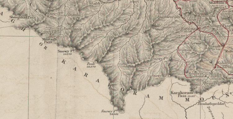 A detail from George
Hayward’s 1870 Sketch Map of Eastern Turkestan
shows the Shimshal ("Shingshal") pass, the Karakorum pass, and
the "Source of the Yarkand River."
The expedition's main goal was to find the Shaksgam River, cross it, survey the Aghil Range on the other side, and get back over the Shaksgam before the summer's glacial melt made it too big to cross. They estimated that this would happen around July 10th. They also wanted to figure out where the Zug (or false) Shaksgam River went, a river whose headwaters a previous traveller, Kenneth Mason, had mapped but had not been able to follow downstream. Crossing rivers was a constant hazard, whether it was the Shaksgam, the Zug Shaksgam, the stream they descend on June 27th in the Aghil range, or the Braldu river in early September. The other limiting logistical factor was fuel. As Shipton related on p. 243, they began with twenty gallons of parafin, but by mid-July most of it had been lost to leaky tins and they had only five gallons left. As they planned Tilman's route to the Snow Lake they saw that they would limited not by food (having over a thousand pounds) but by how much brush and wood they could find. They were always glad to see wood. Tilman in fact noted in chapter sixteen how wrong it felt, when descending the Cornicle glacier, to see a log and not light it on fire. Two previous maps that help one understand what Shipton’s party knew and didn't know are the 1914 map of the Upper Yarkand Valley by the De Filippi expedition, and the 1926 Map of the Shaksgam Valley and the Aghil Range by Mason. Here you can see what the “blank on the map” was.
Shipton never mentions that they were operating for the most part outside British India. "The Shaksgam river lies somewhere on the undemarcated frontiers of Chinese Turkestan, Hunza and Kashmir," he writes in chapter one. I suspect he knew that the watershed divide between the Indus and the Yarkand rivers would be the logical boundary between British and Chinese domains. However in 1937, with China under invasion by Japan and in the middle of a Civil War with the communists, Chinese Turkestan (today's Xinjiang province) was more or less autonomous, and its government had no presence in this remote mountain area. All page numbers refer to the the hardcover Moutaineers/Diadem edition of 1990 (ISBN 0-89886-075-X), a collection of books by Shipton called The Six Mountain-Travel Books. However, it is well worth taking a look at the original 1938 publication of Blank on the Map. There are a number of photographs that do not appear in the 1990 edition, as well as two appendices, one by Auden and one by Spender. The maps are different and, following typical practice at this time, “K2” is invariably sub-scripted as K2.There are also more small drawings. Because the route from Srinagar to Skardu and Askole will be familiar to a reader who is interested in travel in this part of Pakistan, and is well-described in many other books, I begin mapping at Shipton's chapter six. Ways
to view the data
You can use the slippy map above, created in GPS Visualizer. Lines of travel (coloured by chapter) appear on the map and a list of locations (sorted by page number) is on the right. You can download a KMZ file for use in Google Earth. An advantage of the KML file is that it contains view. That is, certain markers, when you double-click on them, bring you in at a certain angle so you can appreciate what could be seen from a certain spot, or give you an angle that emphasizes the terrain. This is perhaps the most satisfying way to view the data. You can download a CSV file of the points and view it in other mapping software. The coordinates are in Lat/long and the datum is WGS84. References
You can download a complete
list of references, but the primary references used in
mapping this journey were the following books and maps. Using
these you can determine perhaps 90% of the described landmarks,
peaks, glaciers, rivers and campsites.
Sources
A number of different publications resulted from the expedition.
Besides the 1990 edition of The Six Mountain-Travel Books
published by The Mountaineers ("Shipton, 1990"), there is
Shipton’s original 1938 book ("Shipton, 1938"), which includes
appendices by both Spender and Auden that do not appear in the
1990 edition. Shipton also read a paper to the Royal
Geographical Society on January 10th, 1938 ("Shipton, 1938,
Geographical Journal," i.e., Geographical Journal vol.
91 p. 313), and to the Alpine Club on January 18th ("Shipton,
1938, Alpine Journal," i.e., Alpine Journal vol. 50, p.
34). Spender and Auden both read papers to the Himalayan Club
("Spender, 1938, Himalayan Journal" and "Auden, 1938, Himalayan
Journal"). These are all available online: see the spreadsheet
of references.It is always delightful to speculate what maps these travellers carried. “Relying on the old map, I had assumed, perhaps unwarrantably, that we were on the Evi Gans glacier,” wrote Tilman (p. 273). I have never seen a map that had an “Evi Gans” glacier. Presumably they carried the Survey of India quarter-inch mapsheet 43 M, but I’ve not found a copy of one of these online. Other
sources mentioned by Shipton
|
||

