 |
|
Map
of Ootsa and Eutsuk lakes for Wistaria Prov. Park
|
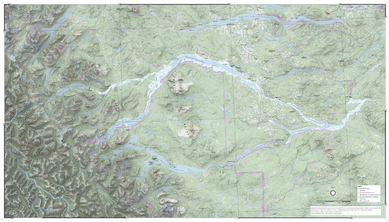 |
In 1952, ALCAN (the Aluminum Company of Canada) built an ambitious series of dams in order to supply its smelter in the coastal town of Kitimat, BC with the large amounts of electricity necessary to make aluminum. The plan involved damming an inland river named the Nechako, a river that flowed east out of the Coast Range, ultimately to the Fraser River and then down to Vancouver. Behind the dam water would back up almost to the coastal watershed, where Alcan bored a massive tunnel west through the Coast Range to convey water to its power plant close to the sea at Kemano. Behind the Kenney Dam, what were originally seven lakes along the Nechako—Natalkuz Lake, Intata Lake, Ootsa Lake, Sinclair Lake, Whitesail Lake, Tahtsa Lake and Tetachuk Lake—became one waterbody. Eutsuk Lake, slightly higher than its neighbours was not affected, and a plan to connect it into the system by digging a canal to nearby Whitesail Lake was never implemented. The Kenney Dam was not designed to allow any water to pass; instead Alcan built a spillway midway along the new reservoir, a spillway that would convey excess water over a low divide into a parallel river system to the north, the Cheslatta. Because of the sudden new high volume of flow in the Cheslatta, Saint Mary's Lake on that river system disappeared and simply became a canyon. First Nations sites were flooded, as were the farms of several Euro-Canadian settlers. Trees along the shore of the Nechako were not cut down, leading to the eerie and hazardous underwater forests for which these lakes are today famous. Some of the flooded area was inside the vast Tweedmuir Provincial Park (although park boundaries were changed as part of the project). Today, BC Parks and the Cheslatta First Nation are designing an interpretive sign to be placed on the shore of Ootsa Lake, at the small Wistaria Provincial Park, to tell the story of the lakes which are gone. I created the basemap for this sign, which is 70 inches wide and 40 inches tall. The map is at a scale of 1:130,000, and I used QGIS 3.14. |
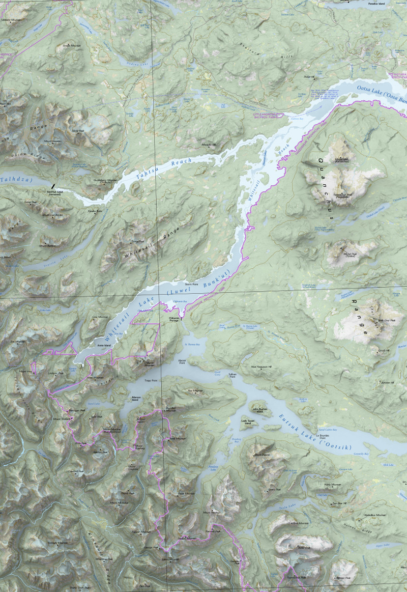 |
Darker blues indicate the original lake-and-river system; light blues are the areas flooded by the dam. But historic geography is not readily downloadable, so I had some sleuthing to do. Polygon data for the present-day lakes I could obtain at DataBC. BC Parks had some info on the original lake shores, and the rest I was able to digitize from pre-1952 topographic maps. The flooded area is its own polygon which sits above the present-day lake polygons. Mike Richardson, historian at the Cheslatta Firs Nation was able to supply me with the locations of temporary dams that were part of construction, and the various spillways, along with Cheslatta settlements which are no longer there. BC Parks was able to give me the historic boundaries of Tweedmuir Park before the 1952 changes. The source for the shaded relief was a set of SRTM 1' DEMs, from 52–54° north and from 125–129°west. Merged, the file was 2.8 GB, and a shocking 26397 x 26555 pixels. I was able to make skymodel hillshades from this, using Raster Chunk Processing. I used the Type 13 illumination model ("standard clear sky, polluted atmosphere"), and the "overcast" model—not because I thought the area was polluted and overcast, but because I find these two hillshades, when blended together make a particularly nice effect. In this case, they are combined by both being at the bottom of the stack, displayed as singleband greyscale, with 50% opacity and a blend mode of Multiply. Most of the labels were hand-placed in Inkscape, but I sped this process up a bit by dividing the CanVec 50K BC Toponymy layer into various categories (e.g., lakes, islands, settlements, peaks) and exporting as SVG the labels for each group. These I could then import into Inkscape on separate layers and position more quickly. |